Acest site nu mai este actualizat. Pentru a deschide site-ul nou urmăriți linkul de mai jos.
This site is no longer updated. To open the new site please click here: geoecomar.ro
Alege limba: Romana
National Institute for Research and Development on Marine Geology and Geo-ecology – GeoEcoMar
 

Seismo-Acoustic, Digital Cartography, GIS, Data Base


Laboratory profile

  • Single beam and multibeam echosounding: acquisition, processing and interpretation
  • Sub-bottom profiling and side scan sonar acquisition, processing and interpretation
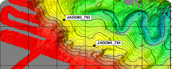
  • Production of digital maps according to national and international thematics or third parties requirements
  • Data structuring and aggregation as GIS and databases

Main activities

  • Fundamental researches for the understanding, deciphering and quantification of sedimentary processes and their dynamics
  • Applicative researches regarding mineral aggregates, gas hydrates, monitoring of dredging activities, river bed maintenance, site surveys for oil and gas drilling platforms, pipelines and cables

Equipments:

  • Single beam: Ceeducer hydrographic system, Elac Hydrostar 4300
  • Multibeam: Elac Seabem 1050D (3 – 3000 m water depth)
  • Sub-bottom profiling: EdgeTech chirp full spectrum sub-bottom profiling system
  • GeoAcoustics digital side scan sonar
  • Linux, Windows servers and workstations
  • Contex A0 color scanner
  • HP A1 color plotter

Software:

  • HydrostarOnline
  • HDPost and HDPedit
  • Fledermaus
  • Global mapper
  • ESRI ArcGis 9.2
  • ESRI ArcView 3.0
  • ESRI ArcInfo
  • Postgres